Tropical Weather Dominating the NE Pacific
23 August 2026 6:10AM PDT
Current Weather Conditions
A powerful high-pressure ridge parked over the Desert Southwest and northwestern Mexico is firmly controlling peninsular weather today, sending inland temperatures soaring while clamping a shallow marine boundary down along our western coast.
Out along the Northern Baja Pacific shoreline, chilly nearshore upwelling waters continue to feed a dense morning stratus deck. However, strong solar heating just across the coastal hills is already generating an active onshore draw, which will pull that low cloud cover and mist back toward the beaches before noon, allowing coastal towns to enjoy a warm, mostly sunny midday stretch.
Along the Gulf of California, sea surface temperatures are simmering at peak summer levels, acting as a massive moisture pump. This warm water foundation, combined with a steady humid drift pushing up from the south, will keep the entire eastern coastline feeling heavily muggy and a lot hotter, driving heat index values through the roof and brewing up afternoon thermal clouds over the mountain crests.
———————-
Regional Forecast for Today
Baja California
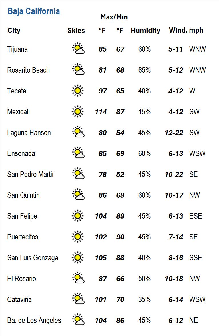
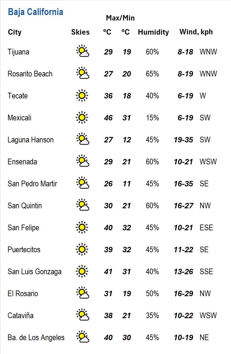
Across the northern state, early morning low marine clouds and patchy shoreline mist will retreat to the immediate beaches by late morning, yielding mostly sunny skies for Tijuana, Rosarito Beach, Ensenada, San Quintín, and El Rosario. Beachside temperatures will stay comfortably warm to warm as fresh afternoon ocean breezes set in out of the west to northwest.
Heading east across the coastal hills, the air will turn noticeably warmer in a hurry. Valley communities and desert floors around Tecate, Cataviña, and Mexicali will experience scorching, a lot hotter conditions under bright sunshine, accompanied by light southwesterly to westerly breezes. Up in the high country, Laguna Hanson and San Pedro Mártir will see mostly sunny skies with pleasantly warm daytime air and brisk mountain breezes, before giving way to crisp, cooler overnight dips.
Over along the upper Gulf of California, San Felipe, Puertecitos, and Bahía San Luis Gonzaga will endure an intensely hot and humid day under sunny skies, with east-southeasterly breezes generating light chop across nearshore waters.
Baja California Sur
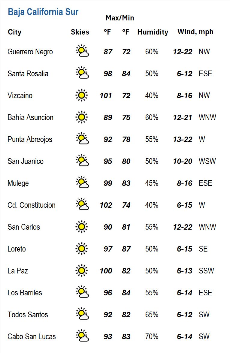
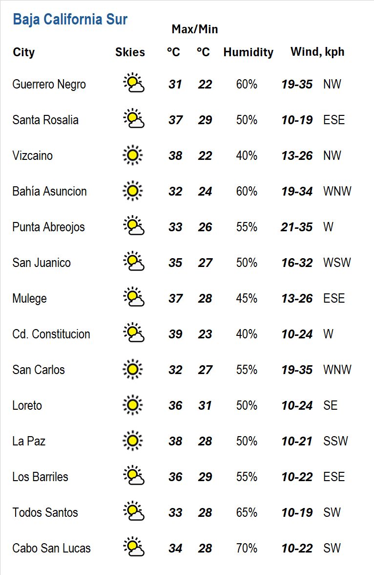
The southern state will remain locked inside an intensely heated, humid setup throughout the day. Central and southern Pacific communities—including Guerrero Negro, Vizcaíno, Bahía Asunción, Punta Abreojos, San Juanico, and Puerto San Carlos—will enjoy mostly sunny to sunny skies, feeling warm to noticeably warmer as you head south, tempered by moderate northwesterly to westerly ocean breezes.
Along the central Gulf coast, very warm surface waters will keep Santa Rosalía, Mulegé, and Loreto feeling heavily humid and a lot hotter under sunny to mostly sunny skies, accompanied by gentle southeasterly breezes.
Down across the southern tip, rich subtropical moisture will leave Ciudad Constitución, La Paz, Los Barriles, Todos Santos, and Cabo San Lucas feeling heavily muggy and a lot hotter. Skies will transition from mostly sunny to partly cloudy by early afternoon, with unstable air triggering scattered showers and localized thunderstorms over the interior ridges that could drift into surrounding foothill communities and coastal plains before evening.
———————-
7-Day Forecast
Through the remainder of the weekend, the peninsula will hold to an established late-summer weather pattern. Pacific coastal communities will see morning fog and low stratus burn back toward the beaches by mid-morning, providing pleasantly warm, mostly sunny afternoons. In contrast, inland valleys, desert floors, and the entire Gulf of California shoreline will stay locked in fierce heat, feeling a lot hotter and heavily muggy under intense sunshine.
As we move into early next week, dominant high pressure aloft over the southwestern border will continue suppressing the marine inversion while keeping inland desert readings running well above average. Meanwhile, a steady surge of monsoonal moisture lifting up the Gulf will elevate humidity levels, support muggy overnight lows, and fuel afternoon cloud buildups with scattered thunderstorms over the central cordillera.
By the middle and latter half of the week, as organized tropical energy tracks across open waters to our southwest, a deeper moisture shield will spread across Baja California Sur. This will bring expanded cloud cover, higher humidity, and daily chances for mountain-induced showers and thunderstorms, while keeping evening air very warm and sticky. Mariners and beachgoers should maintain caution, as building southern swell energy will continue delivering powerful surf and treacherous rip currents to exposed southern and western coastlines.
———————-